2026 State of the Borderlands Report
There are few places where one can see the entire movement corridor for a large mammal, but the view from Montezuma Pass at Coronado National Memorial is one such place. The pinch point for the third-largest cat on earth, the jaguar, is visible in every direction. Standing atop 6,871-foot Coronado Peak on a clear day, you can see the highest peaks of the Northern Jaguar Preserve 120 miles to the south in the Mexican state of Sonora.
Eighty miles to the west lies Baboquivari Peak, the spiritual center of the universe to the Tohono O’odham people, and the westernmost recent jaguar record, in 2009. Looking to the eastern horizon lies the Sierra San Luis Mountains, the northernmost outpost of the great Sierra Madre Occidental, which crosses the U.S.-Mexico border in the bootheel of New Mexico and forms the Continental Divide. The big spotted cats still thrive there, a stone’s throw south of the border.
Looking west from Coronado Peak, you see the broad San Rafael Valley, 2,000 feet below, give birth to the Santa Cruz River, a true binational river that crosses the border twice, both north and south.

Myles Traphagen
The crowns of cottonwood and willow trees, which sprout from mile-high blue grama grasslands and provide homes for porcupines, are sparse in the valley before the river’s watershed gathers strength on its 30-mile foray south into Mexico before returning to the U.S. at Kino Springs, flowing north along the De Anza Trail, which parallels present-day Interstate 19 between Nogales and Tucson.
The view to the east of Coronado National Memorial is equally awe-inspiring, taking in the lush green riparian cottonwood gallery of the San Pedro River, which flows north from Sonora into Arizona toward the confluence of the Gila River, 120 miles north.
The epic grandeur of these mountain ranges would not exist without the grassland and desert valleys that lie between them. These are the Sky Islands, or the Madrean Archipelago, a globally recognized biodiversity hotspot where the Neotropical and temperate zones converge.

Grigory Heaton
An Elegant Trogon in Santa Rita Mountains, Coronado National Forest.
The Heartland of North America
Six distinct biomes occur across the 50 or so mountain ranges that span the states of Arizona, New Mexico, Sonora and northwestern Chihuahua. Half the bird species in North America are found here, and the degree of endemism is high — many plants and animals occur nowhere else. This place is not the borderlands but the Heartland of North America.
“This place is not the borderlands but the Heartland of North America.”
The Sky Islands have existed largely unchanged for millennia. But this is rapidly changing today. The border wall is slicing through this landscape at an unprecedented rate. The destruction it will inflict is beyond comprehension. Our study with Sky Island Alliance found that the border wall reduced wildlife movement by 86% compared to vehicle barriers. Never before has a continuous barrier been built, severing the wildlife corridors of an entire continent.

Myles Traphagen
A Wall Across a Continent
In July 2025, Congress allocated $47 billion for border wall construction. Add the $16 billion spent between 2017 and 2021, and the total tops $60 billion.
To put these incomprehensible numbers into perspective, consider this: In today’s dollars, the Panama Canal cost $12 billion, the Hoover and Glen Canyon dams $1 billion each, and the Grand Coulee Dam, the most expensive, $6 billion. That’s $20 billion, about a third of more than $60 billion spent on border walls. Add in 24 Essex-class aircraft carriers from World War II — the Yorktown, the Hornet — at a billion each, and we’re still only two-thirds of the way to the sum spent on a structure whose only purpose is to divide.
Money is one thing, but for wildlife, precious groundwater and our protected public lands, the cost is incalculable. This massive public works project, largely out of sight and out of mind to the American public, is an unprecedented crime against nature. We are walling off, dividing and altering the history of the North American continent.

Myles Traphagen
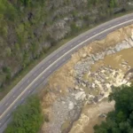
Aerial view of large-scale excavation near the U.S.-Mexico border.
Myles Traphagen
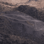
Dynamite blasts at Coronado National Memorial. Sierra Vista, AZ.
Myles Traphagen
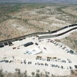
Double border wall construction in Patagonia Mountains. Santa Cruz County, AZ.
The Department of Homeland Security plan, now moving at a frenetic pace, is to build 2,100 miles of primary and secondary border walls. It’s not just one wall, but two parallel 30-foot-high border walls running from the Pacific Ocean to the Gulf of Mexico, slicing through the most biodiverse places on the continent.
No Place Is Safe
How can this happen in America, the global pioneer of conservation and careful resource management?
Aren’t national parks, wilderness areas and national wildlife refuges protected from destruction? Sort of. In a catastrophic lapse of foresight and wisdom, in 2005 the U.S. Congress passed the REAL ID Act. In an obscure but gravely consequential piece of this legislation (Section 102), authority was granted to the Secretary of Homeland Security, an unelected, politically appointed official, to waive all cultural, historical and environmental protection laws to build border barriers.
A group of us observed the outcome of this fateful act while perched atop Coronado Peak on a windy day in December, the kind of crisp winter air that polished the blue sky into 4K resolution. At the top of the hour (as is blasting protocol), the ear-splitting concussion of dynamite blasts that dislodged boulders the size of Volkswagen Beetles interrupted the peace and tranquility that our national parks were intended for. As the dust cleared and our throats still clenched after witnessing the irreversible destruction of a place that has loomed large in our cultural and natural history, we realized that no place is safe from the wrath of border walls.
Nothing is sacred.
“As the dust cleared and our throats still clenched after witnessing the irreversible destruction of a place that has loomed large in our cultural and natural history, we realized that no place is safe from the wrath of border walls.”
A Landscape Older Than Borders
First designated in 1941 as the Coronado International Memorial, the site was meant to anchor an adjoining binational park in Mexico, like the Waterton-Glacier International Peace Park between the U.S. and Canada. The proposal never gained traction because of a lack of interest from the Mexican government and the ensuing war, which began only four months after the idea was conceived.
Even though the international memorial was never realized, Coronado National Memorial was designated in 1952 to commemorate the Coronado expedition, which arrived in the San Rafael Valley in 1540, centuries before the United States and Mexico existed. The Spaniards were in search of Cibola, the Seven Cities of Gold, and they eventually made their way up to present-day Salina, Kansas, before returning to Mexico City without gold.
Along the way, the expedition documented the great diversity of wildlife that we still see here today, including ‘cibola,’ the American Spanish word for bison. The place Coronado first rested his eyes upon nearly 500 years ago has remained mostly unchanged — until now.


Wildlife Still Searching for Passage
The destruction of mountains and rock scars the landscape and directly harms the plants and animals that live there, but the impact of border-wall construction on wildlife and water resources is far-reaching. Modern humans, however, are a resourceful species and can protect and care for other members of the plant and animal kingdoms.
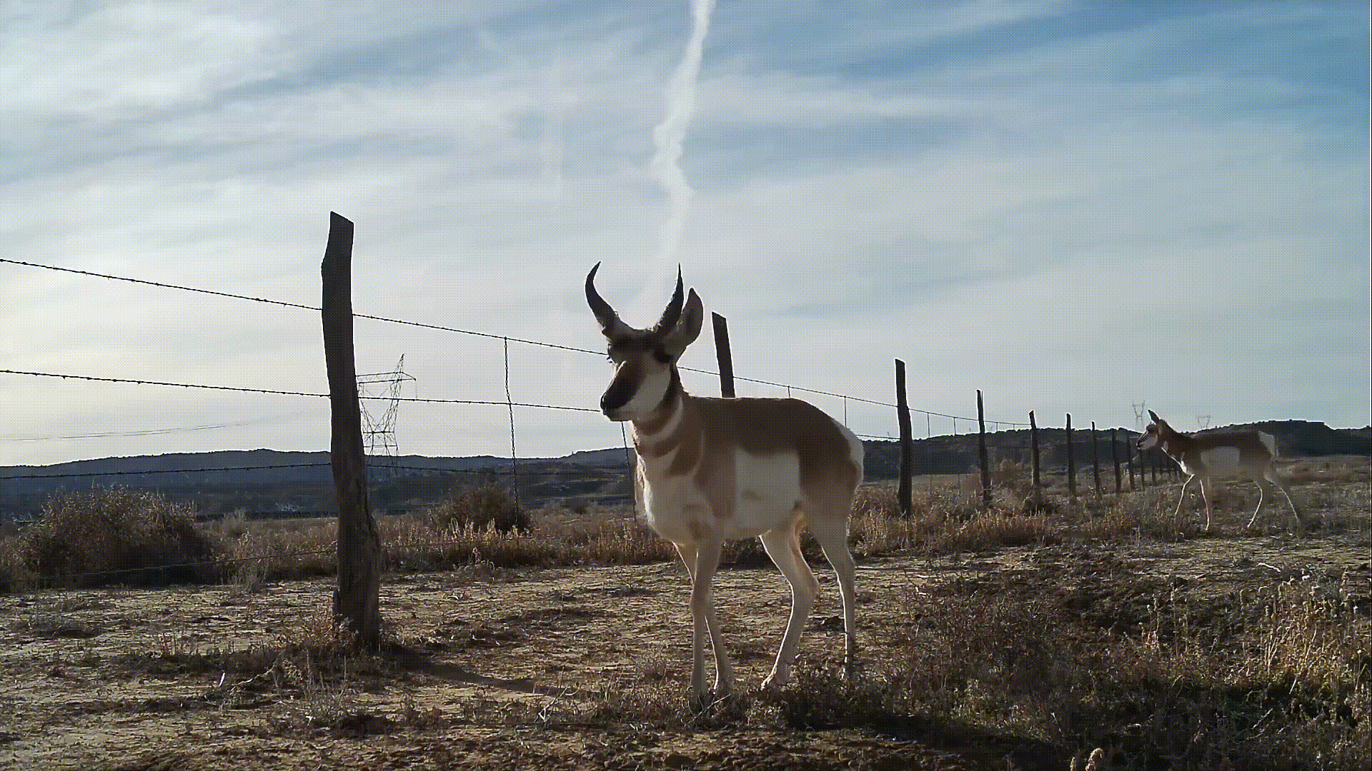
In 2023, an agreement was reached between the Department of Homeland Security and plaintiffs from the Sierra Club, the ACLU and 19 U.S. states, establishing large and small wildlife passages through the border wall. For the past five years, Wildlands Network and Sky Island Alliance have monitored wildlife at these openings, with surprisingly positive results.
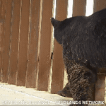
Despite their small size — 8-by-11-inch openings — many small and medium-size mammals can use them to pass through. Larger species, however — deer, pronghorn, black bears, large mountain lions and Gould’s turkeys — cannot fit through these small openings. They require large openings, which we have monitored, documenting the movement of all the species named above.


What Comes Next
We must push hard for large wildlife openings so these animals have a chance to survive. They have no voice, so it is up to us to advocate for them to be restored, reconnected and rewilded.
Throughout 2026, Wildlands Network will continue documenting the impacts of border wall construction on wildlife corridors, public lands and water resources across the U.S.-Mexico borderlands.
The Sky Islands are still connected in places. But the window to protect them is closing rapidly.
What happens here will shape the ecological future of North America for generations to come.

Sky Island Alliance/Wildlands Network

Stay Wildly Connected
Join a movement that’s rebuilding the wild foundations of our continent. Your involvement fuels science, advocacy, and real change on the ground.
Join Us
Myles Traphagen
Related Posts

Ron Sutherland