Protecting Private Working Lands: Essential Strategy for Wildlife Connectivity in Northeast California
The Highway 395 corridor in northeastern California is a landscape defined by movement. Each year, herds of mule deer travel dozens of miles between the high-elevation meadows of the Sierra Nevada in summer and the lower-elevation Great Basin in winter. Pronghorn, mountain lions, and even gray wolves, now beginning to return to their historic range in California, also depend on these connected habitats to find food, water, and mates.
Much of the land that makes these movements possible is privately owned. As development and other land-use pressures increase, these privately held natural areas that wildlife have moved through for millennia are at risk of being lost. This concern is compounded by existing challenges such as habitat fragmentation and road-related mortality from Highway 395.
That’s why avoiding conversion of private lands and keeping working lands working is such an important piece of the puzzle. Protecting and connecting these properties can safeguard migration corridors and ensure that wildlife from mule deer to mountain lions can continue to move safely across this essential landscape.
Ongoing Collaborative Conservation
Wildlands Network and our partners have long recognized the need to improve connectivity for wildlife along the Highway 395 corridor. Over 40 years ago, Caltrans pioneered some of California’s first wildlife underpasses on Highway 395 in Lassen County, which were designed to help mule deer safely cross the increasingly busy road.
Photo by Pathways for Widlife
Building on that early work, Wildlands Network has supported several connectivity projects in the corridor. From 2021 to 2024, we partnered with Pathways for Wildlife to study how wildlife interact with existing road infrastructure along a 53-mile stretch of Highway 395. Together with prior research, such as California Department of Fish and Wildlife’s mule deer telemetry studies and Caltrans’s roadkill data, our findings have informed recommendations for new wildlife crossing structures, including several planned bridge and culvert upgrades from Caltrans.
In parallel, we are also collaborating with the Lassen County Transportation Commission’s project team to plan and design a wildlife overcrossing to provide a safer route for mule deer and other species to access essential habitat.
We have also supported our partners at Backcountry Hunters & Anglers and the Honey Lake Resource Conservation District secure funding to conduct post-fire remediation and habitat restoration in critical movement corridors and winter range.
Despite these efforts, persistent threats like habitat loss and development pressures are driving continuing wildlife population declines. To further support wildlife, we must also protect and restore key habitat areas, seasonal ranges, and mule deer migratory pathways.
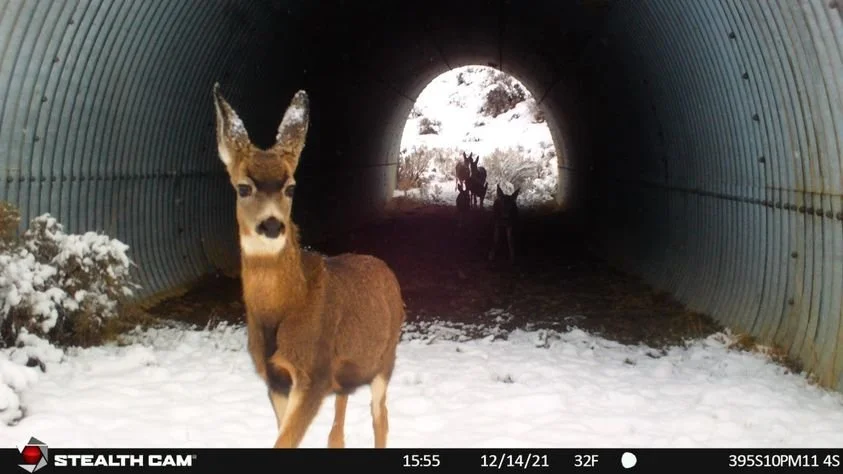
Several existing culverts facilitate safe passage across Highway 395, and we are working on building more crossings. Photo by Pathways for Wildlife
Prioritizing Private Land for Protection
While we have a strong understanding of broad movement patterns — thanks in large part to California Department of Fish and Wildlife’s GPS collaring of mule deer — we still lack fine-scale information about which private lands are most critical for wildlife movement and habitat in this region. Many local land trusts, Tribes, and government partners are already working to advance voluntary conservation and improve wildlife health in the region. However, without clear, parcel-level guidance, it can be difficult to ensure that conservation investments are strategically directed toward the properties that will make the greatest difference for connectivity.
That’s why Wildlands Network is launching an ambitious new project: a private land protection prioritization analysis for the Highway 395 corridor.

The goal is to leverage wildlife connectivity expertise to help our local partners pinpoint the privately held parcels most critical for maintaining and enhancing wildlife connectivity. Using GIS-based analysis, scientists from Jodi McGraw Consulting will map and evaluate parcels across the region based on their ecological and strategic values. Key questions include: Does the parcel overlap with known migration corridors? Does it connect existing protected areas? Does it provide critical winter range habitat? Is it threatened by development? By scoring and ranking parcels according to these criteria, the analysis will guide future land acquisition and conservation efforts.
This will be a collaborative process. Federal and state agencies, Tribes, land trusts, and local partners will help shape the analysis, share local knowledge, and refine priorities to ensure the outcomes reflect community values and conservation goals.
Looking Ahead
Over the next year, the project will move through key milestones: designing the prioritization framework, building the GIS database, scoring and ranking parcels, and producing a final report and interactive maps. By spring 2026, we’ll have a powerful tool to advance data-driven conservation planning and investments along the Highway 395 corridor for decades to come.
Together with ongoing road ecology and connectivity projects, this initiative will help protect and restore the seasonal pathways and year-round habitats that mule deer, pronghorn, mountain lions, wolves, and other species need to survive, ensuring that the Highway 395 corridor is a landscape where wildlife can move freely and safely for generations to come.